Phoenix historic districts:
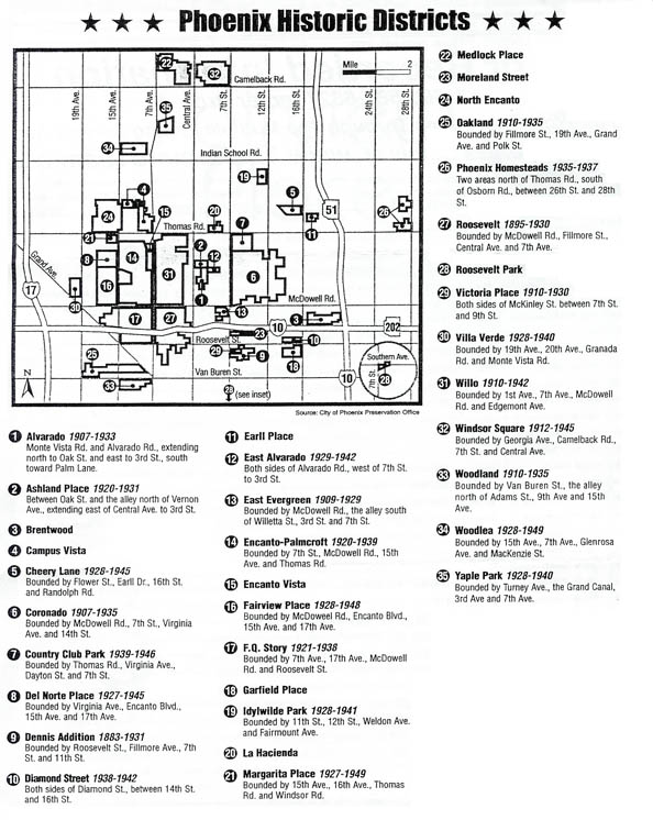
Alvarado (key streets: Monte Vista, Alvarado, Oak, Third Street, Palm Lane) 1907-1933.
Ashland Place (key streets: Hoover, Vernon, Ashland Avenues, Central Avenue, Third Street) 1920-1940.
Brentwood (key streets: 16th, 20th Streets, Culver, just north of Brill Street) 1926-1956.
Campus Vista (key streets: Thomas, Osborn Roads, Seventh, 15th Avenues) 1939-1956.
Cheery Lynn (key streets: Flower Street, Earll Drive, 16th Street, Randolph Road) 1928-1945.
Coronado (key streets: Seventh, 14th Streets, Virginia Avenue, just north of McDowell Road) 1907-1942.
Country Club Park (key streets: Thomas Road, Virginia Avenue, Dayton Street, just west of Eighth Street) 1939-1946.
Del Norte Place (key streets: Virginia Avenue, Encanto Boulevard, 15th, 17th Avenues) 1927-1945.
Earll Place (key streets: Earll Drive, Pinchot Avenue, 16th, 18th Streets) 1927-1942.
East Alvarado (key streets: Alvarado Road, Third, Seventh Streets) 1929-1942.
East Evergreen (key streets: Third, Seventh Streets, McDowell Road, just south of Willetta Street) 1909-1929.
Encanto Palmcroft (key streets: Seventh, 15th Avenues, McDowell Road, Encanto Park Golf Course) 1920-1939.
Encanto Vista (key streets: Windsor Avenue, Encanto Boulevard, Seventh, Eighth Avenues) 1943-1953.
Fairview Place (key streets: McDowell Road, Encanto Boulevard, 15th Avenue, just west of 17th Avenue) 1928-1948.
F.Q. Story (key streets: McDowell Road, Roosevelt Street, Seventh, 17th Avenues) 1921-1942.
Garfield Place, aka Victoria Place, (key streets: Roosevelt, Van Buren, Seventh, 16th streets, 1883-1942.
Idylwilde Park (key streets: 11th, 12th Streets, Weldon, Fairmount Avenues) 1928-1941.
La Hacienda (key streets: Verde Lane, Catalina Drive, Third, Seventh Streets) 1926-1954.
Los Olivos (key streets: Monte Vista Road, Third, Seventh Streets) 1906-1935.
Margarita Place (key streets: Thomas Road, Windsor Avenue, 15th, 16th Avenues) 1927-1949.
Medlock (key streets: Seventh, Missouri Avenues, just west of Central Avenue, just south of Pasadena Avenue) 1926-1956.
North Encanto, aka Westwood Village (key streets: Osborn Road, Thomas Road, 15th Avenue, just west of 18th Avenue) 1939-1950.
North Garfield, aka Diamond Street, Morel Street (key streets: Interstate 10, Roosevelt Street, Seventh Place, 16th Street, 1887-1942.
Oakland (key streets: Grand Avenue, 19th Avenue, Fillmore Street, just north of Van Buren Street, 1887-1935.
Phoenix Homestead (key streets: north of Thomas Road, south of Osborn Road, 26th, 28th streets) 1935-1937.
Pierson Place (key streets: Camelback Road, Grand Canal, Central, Seventh Avenues) 1924-1956.
Roosevelt (key streets: McDowell Road, Fillmore Street, Central, Seventh Avenues, 1895-1930.
Roosevelt Park (key streets: Seventh, Ninth streets, Old Southern Avenue, just north of Southern Avenue) 1924-1942.
Villa Verde (key streets: 19th, 20th Avenues, just north of Monte Vista Road, just south of Granada Road) 1928-1940.
Willo (key streets: First, Seventh Avenues, McDowell Road, just north of Edgemont Avenue) 1910-1950.
Windsor Square (key streets: Central Avenue, Seventh Street, Camelback Road, just north of Oregon Avenue) 1912-1945.
Woodland (key streets: Seventh, 16th Avenues, Van Buren Street, just north of Adams Street) 1880-1935.
Woodlea (key streets: Mackenzie Drive, Heatherbrae Drive, Glenrosa, 15th Avenues, just west of Seventh Avenue) 1928-1949.
Yaple Park (key streets: Turney Avenue, Grand Canal, Third Avenue, just east of Seventh Avenue) 1928-1940.
Click here to see photos of homes in this area.